Natural Hazards
Floods
Prepared by ECRP – European Center for Risk Prevention (Sofia, Bulgaria) & the Editorial Board.
A flood involves water temporarily covering land that is usually not covered in water.
This includes floods caused by watercourses (e.g. rivers, mountain springs, streams that are normally dry) unable to cope with excessive water input.
Most of this input comes from heavy rainfall but other sources (such as coastal tides, storm surges or tsunamis) may also lead to flooding. Overflowing of sewer systems is not regarded as floods. Floods are a potential cause of incidents and population exoduses, inflicting damage on the environment and seriously disrupting economic development.
A “flood” means water temporarily covering land that is usually not covered in water. This includes floods caused by rivers, mountain and Mediterranean water streams that are normally dry, intensive melting of ice/glaciers as well as flooding of coastal areas by the sea. A flood originates mainly from heavy or prolonged rainfall and can have significant effects on the water load of rivers, streams and canals.
A stream can swell up and overflow, i.e., break the banks, flooding the surrounding areas. Not all of the streams, however, appear and behave in the same way. Torrents, for example, become rivers only when it rains a lot. With decreasing rainfall, the water level can decrease and leave the riverbed dry.
Floods are a potential cause of incidents and population exoduses, inflicting damage on the environment and seriously disrupting economic development. In general, floods have more serious effects in urban centres. Although floods are triggered by natural phenomena that cannot be prevented, their negative consequences can be reduced.
“Flood risk” means the combination of the possibility of flooding and the potential negative consequences for human health, the environment, cultural heritage and economic activity connected with flooding.

Depending on the underlying causes, floods can generally be divided into three groups:
First group: floods caused by heavy or prolonged rainfall or intensive melting of snow, ice/glaciers;
Second group: floods caused by strong wind. These occur along sea coasts and river sections flowing into the sea;
Third group: floods caused by underwater earthquakes and, less frequently, the eruption of underwater or island volcanoes. The underwater earthquakes and eruptions can cause large waves (tsunamis) that often result in coastal flooding.
The main types of floods are distinguished as follows:
– Riverine flooding (river floods)
These floods occur around river beds. They are the most frequent, with several different kinds of riverine floods (go to 2.1).
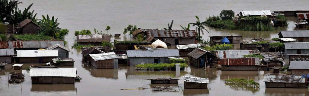
– Floods caused by local drainage or high groundwater levels
Floods caused by local drainage or high groundwater levels, urban floods (Fig.2).
This type of flood is caused mainly by poor maintenance/control of hydraulic systems, or poor conditions in built-up areas. Floods of this kind destroy normal living conditions and cause economic losses.
Local heavy precipitation may produce flooding in areas other than delineated floodplains or along recognisable drainage channels. If local conditions cannot accommodate intense precipitation through a combination of infiltration and surface runoff, water may accumulate and cause flooding problems.
High groundwater levels may be of concern and can cause problems even where there is no surface flooding. Basements are susceptible to high groundwater levels.
– Floods caused by fluctuating lake levels
Floods of this kind usually spread over vast flat areas close to coasts of lakes and last a long time. Climate change influences the frequency and extent of this flood type because the hydrological cycle is interrupted.
Water levels in lakes can fluctuate on a short-term, seasonal basis, or on a long-term basis over periods of months or years. Heavy seasonal rainfall can cause high lake levels for short periods of time, and melting can result in higher spring levels. Long-term fluctuations are a less recognised phenomenon that can cause high water and subsequent flooding problems lasting for years or even decades.
– Coastal flooding Coastal flooding in combination with other flood types (mainly riverine) results in floods with huge losses (go to 2.2).
The term “devastating flood” is used to describe any of the above-mentioned floods that cause enormous human and economic losses.
Riverine flooding includes:
– Overflow from river channel or river floods
This kind of floods are with highest frequency. They are caused by bank overtopping when the flow capacity of rivers is exceeded locally. (Fig. 2.1 a)
The activity of the local authorities for the prevention of flood risk is most important to reduce the consequences.
The general factors affecting the river floods are the intensity and the duration of the rainfall, the possibility of rivers and steams to let pass the rising waters, the condition of the land surface – soil and vegetation, topography, etc. The river floods occur at the higher scale of the rainfall system, where the permeability capabilities of the multitude of smaller tributaries are gradually filled up and the water peak is usually gradually collected and transported to the larger river.
The lengthy rivers flow through flat terrain and the water movement speed is low. The same applies in the occurrence of a flood; the water peak is reached very slowly and afterwards it fades down very slowly over the course of a few days to a few weeks. Usually the reason for the flood is intensive and prolonged rainfalls occurring in other regions, often in other countries within the fluvial catchment area. The situation becomes even more complex when the heavy rainfall continues along the river. These floods are predictable as they are usually of seasonal character and this allows for the proper organization of actions aiming to decrease the consequences.
– Flash floods
There are floods caused by heavy rainfall taking place within a short timeline.
During the last decade, the frequency of these kinds of floods has increased with climate change.
Such floods are harder to predict and they can occur in dry places where there is no running river. Such floods can prove to be very dangerous since they start suddenly and develop very rapidly.
In the case of flash floods, the reaction is mostly hindered by the very short time between their origination/continuous heavy rainfall/ and the reaching of the water peak in a short time.
The flash flood is characterized by the rapid increase in the water level, the high speed and large quantity of debris in water, giving the flood a high destructive power. The main factors causing the origination of a flash flood are the intensive and continuous rainfall and the steep water sheds.
In certain regions the flash floods often result from isolated high-speed local rainfalls, rendering the warning and protection of the population a very difficult task. In other regions such floods occur annually in one and the same river, where warning the population is possible, but advance organization is needed, since the reaction time is quite short. Flash floods are capable of tearing out trees, undermining buildings and bridges and scouping new chanels.
During the month of April 2020, Yemen has experienced heavy rains which caused flash floods in different areas of the country. At least 150,000 people were affected and according to the health authorities seven people died. More recently, on 5th august 2020, at least 17 people, including 8 children, have been killed in flash floods in Yemen’s northern region.
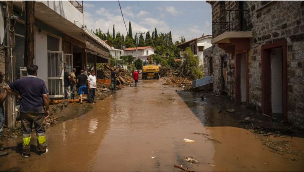
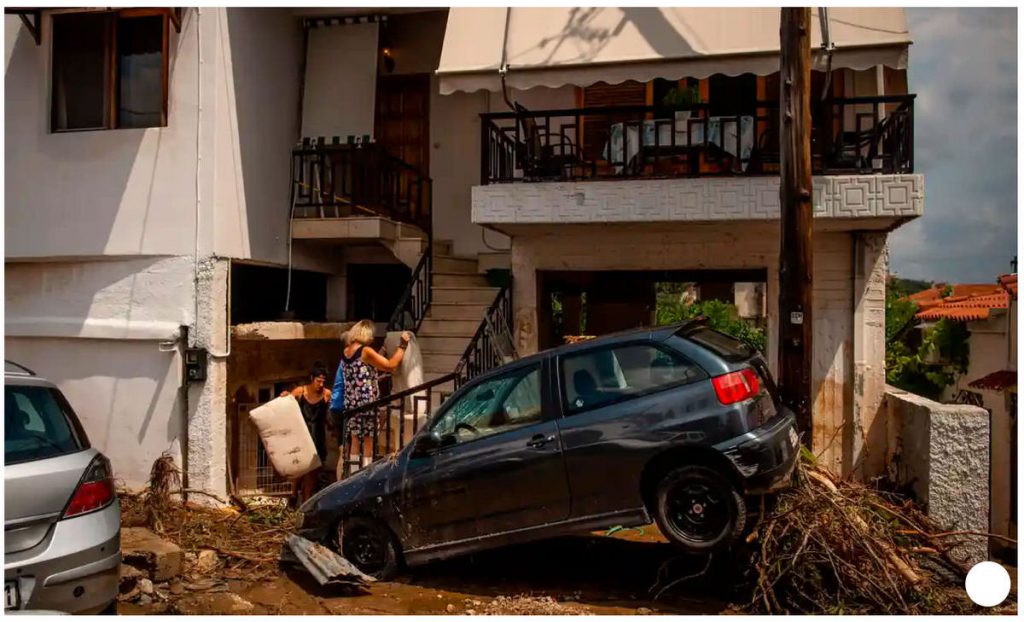
On 9th august 2020, heavy rains and thunderstorms have caused flash flooding on the on Greek Island of Evia, killing at least seven people including a baby (See Fig. 2.1 b). The news was posted on 10th august 2020 also in the https://www.facebook.com/BeSafeNet.
– Alluvial fan floods
This type of flooding is typical for mountain and volcanic areas and rare for other regions.
Alluvial fan floods which adversely affect people lives usually occur when the threatened areas are at the passage between the mountain and flat areas or mountain and seacoast. When the requirements for the building works are not respected, there is a lack of control and the prevention plans are a formality. The consequences are always very destructive and with many victims e.g., in Venezuela in 1999, 19 000 people died.
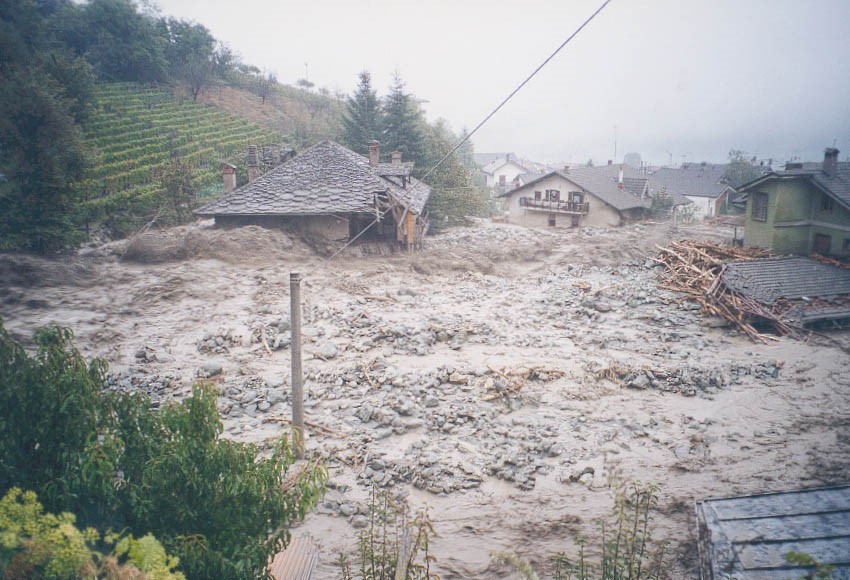
The common torrents pass through the main riverbed and most of them have a stone-muddy structure. They are particularly dangerous since they often pass through urbanized areas (Fig.2.1 c). Their most dangerous characteristics are the suddenness, the straightforwardness of movement and the transportation of large quantities of hard materials, which pile up on, or destroy along their way settlements, roads, railway tracks, engineering equipment and agricultural lands.
The destructive forces of the torrent are defined by the increased capability to transport hard materials, the interruptibility of the movement, the high velocity of up to 15km per hour.
The human activity, related to the intensive use of mountain slopes leads to the increase in the volume and frequency of this type of flood, as well as to the increase in the number of locations where they can occur.
Alluvial fan floods. Their name/fan/ corresponds to the shape of the spreading mass. In substance they are the same as the above described but the solid mass prevails and they are more similar to the landslide.
Alluvial fan floods can cause greater damage than typical riverine flooding.
– Ice-jam floods
Floods caused by fast melting of ice/glacier. This kind of flooding in most cases can be predicted and this allows for organizing and undertaking measures for lowering of the consequences.
Serious damage is caused by river floods owing to the combination between rising waters and ice movement. The ice movement is usually accompanied with jamming/filling up of the riverbed with ice or by the accumulation of intra-water ice, forming an icy barrier, which in turn causes an additional increase in the water level and the flooding of new territory upstream. Furthermore, in case of breach of the ice barrier a powerful wave is created that could suddenly flood the territories located downstream.
The jamming of the river by ice occurs most often in rivers flowing from south to north such as the Oder, Wisla, Ob, Yenisei, Lena, Yukon and others.
This is explained by the fact that the southern parts of the river free themselves earlier than the northern sections, in the course of which the moving water, mixed with ice, meets an obstacle of fully frozen sections. Ice barriers can also be created at the beginning of the winter prior to the complete freeze, when there are still sections of the river that are not frozen yet. Sometimes this type of flood can occur in lengthy rivers flowing from west to east e.g., the Danube, and Amur.
The origination of such floods depends on the climate and the physical condition of the river valleys. The freeze is lesser where the waterside is higher and steeper. The freeze is usually more severe in dams, in engineering equipment, at the turns and bridges and at places where the river has low depth over a long distance.
For such type of floods, the estimated reaction time is rather short, requiring an obligatory and serious advance preparation. Since the locations of the ice jams will be known in advance thanks to long years of experience, precaution measures can be taken long time before the start of the ice movement in the river.
The elimination of the ice barriers is done through detonations or by using an ice-breaker, if possible.
– Dam-break floods
They happen very rarely but cause a high number of casualties. The permanent control of the hydro technical installations and organization of the announcement and protection of the threatened population are of great importance.
It is worth noting that the big flooding that occurred during the last two decades in most cases are the result of a combination of different kinds of floods, usually among the river flood and other kinds of flood as: provoked by a string wind, intensive and long lasting rainfalls, Monsoon, sea inflows, increase of the level of the underground waters or destruction of the functions of the drainage channels and other.
The breaking of a dam wall, especially of large dams, is rather rare and can hardly be foreseen. The overflow of water from medium- and small-seized dams is an event occurring more often as well as the breaking of the of land type walls of the small dams.
The floods caused by break of walls of large dams can be very dangerous since they can affect the life of a lot of people.
The breaking of a dam wall can occur in the case of a breach in the construction as a result of progressive erosion in the wall, destruction of the embankments /dikes. A construction breach can also occur in the event of a particularly severe flood. The dam walls are designed to withstand a powerful earthquake, but even so, an earthquake can extremely weaken the wall.
The floods caused by a dam wall break, due to their unexpectedness and high water speed, can inflict casualties and destruction comparable only to a natural disaster. This is the reason why the large dam walls are placed under constant control and surveillance with special equipment installed inside the wall, monitoring for any deviation in the facility’s parameters. Furthermore, the dam walls have inbuilt automated systems for warning the population about danger.
These are cases of floods at the riverbed after the dam wall which is not broken. Such a flood happened in Italy in 1963 when a huge landslide into Vaiont Dam pushed out the dam water which spilled over the dam wall without breaking it but causing catastrophic flooding in which 3000 people died.
The local authorities obligatorily have to include all dams in the protection plans.
In most cases, the smaller dams used for watering and other activities cause major problems. Usually their walls are of land type and require permanent maintenance and control of installations. When such walls are poorly maintained, they become very dangerous during intensive rainfalls or intensive snow melt. The local authorities have to keep records of such dams, to control permanently and to make organization for risk prevention.
For more information please click
http://www.besafenet.net/en-gb/technological-hazards-dam-failures#faq199
Of all river floods this is the one that is the most frequent.
The general factors affecting the river floods are: the intensity and the duration of the rainfall, the possibility of rivers and steams to let pass the rising waters, the condition of the land surface – soil and vegetation, topography and others. The river floods occur at the higher scale of rainfall system, where the permeability capabilities of the multitude of smaller tributaries are gradually filled up and the water peak is usually gradually collected and transported to the larger river.
These floods can be divided into two groups, depending on the form of the water-collection area and the length of the river:
- The first group includes floods occurring in lengthy rivers /Nile, Danube, Euphrates, Mississippi, Rhine, and others.
- The second group includes floods occurring in rivers with round shape of the water-collection basin /Congo/.
The lengthy rivers flow through flat terrain and the water movement speed is low. The same applies for the occurrence of a flood, the water peak is reached very slowly and afterwards it fades down very slowly over the course of few days to few weeks. Usually the reason for the flood is intensive and prolonged rainfalls occurring in other regions, often in other countries. The situation becomes even more complex when the heavy rainfall continues along the river. These floods can be predicted, they are usually of seasonal character and this allows establishing a proper organization to decrease the consequences.
In the case of rivers with round water-collection basin, after heavy rainfall the water peak reaches its highest value quickly and quickly decreases. Such floods usually happen in small and average sized rivers. Usually they are much more destructive because the water moves with higher speed.
The above examples refer to smaller rivers with similar characteristics.
Flash floods are often associated with isolated and localised intense rainfall. But Flash floods may result from the failure of a dam or the sudden breack-up of ice jam. Flash floods in urban areas is serios problem too.
The change in the climate has increased the floods of this type. Such floods are harder to predict, they can occur in dry places where there is no running river. Such floods can prove very dangerous since they start suddenly and develop very fast.
In the case of flash floods the reaction is mostly hindered by the very short time between their origination /continuous heavy rainfall/ and the reaching of the water peak in short time.
The flash flood is characterized by the fast increase in the water level, the high speed and large quantity of debris in water, giving the flood a high destructive power. The main factors causing the origination of a flash flood are: the intensive and continuous rainfall and the steep water sheds.
In certain regions the flash floods often result from isolated high-speed local rainfalls, rendering the warning and protection of the population a very difficult task. In other regions such floods occur annually in one and the same river, where warning the population is possible, but advance organization is needed, since the reaction time is quite short. Flash floods are capable of tearing out trees, undermining buildings and bridges and scouping new chanels.
Mountain torrents occur at intensive rains for long and short time in the mountain areas. This happens because the river bed slop is big, the water runs fast and carry with itself dispersive mass.
The improvement of the forecast systems already gives opportunity for announcement and information of the population at the threatened zones in most cases.
The above mentioned floods appear mostly at the rivers or dry river valleys they are included in the group of the river flooding.
Alluvial fan floods is a temporary spring formed in the beds of the mountain rivers, characterized in the sharp increase in the water level, which has a high content /10 to 75%/ hard particles /soil products and rock decomposition products /.
This kind of flood originate as a result of intensive and continuous heavy rainfall, swift melting of the seasonal winter cover or of glaciers, as well as due to the landslide of loose, cracked rock material /at terrain inclination of no less than 8 – 10%/.
Depending on the content of the torrent mass we can specify the following torrents: stone-muddy, water-stone and water-gravel. Besides that as a physical phenomenon they can be free or latent. The transporting medium of the free torrents is water with hard admixtures /Mud-steam/, and for the latent ones the medium is the soil mixture where the main water mass is connected with finely dispersed particles (Mud-flow, Debris flow) Mud-rock flow and Alluvial fan floods – the contents of the mass is mostly soil and rocks/stone –mud/.
In contrast to the regular flows, flows of the mass by default do not move permanently, but in separate waves /pushes/. The volume of the one-time mixture, transported with high velocity, may vary from hundreds of thousands to millions of cubic liters. The front of the moving mixture can have a diameter of 3-4 meters, and mass of 100 – 200 tons. With their large mass and movement speed this mass destroy roads, equipment, agricultural land and others.
The causes for the origination of this kind of flood are mainly the heavy rainfall, the accumulation of masses of crumbly and cracked material, the increase of the intensity of the surface water outflow.
The practice has demonstrated that the centre of this kind of flood/accumulated soil and rock masses/ starts to move after overcoming the resistance of the terrain and other obstacles, that are destroyed by the rain waters, and the rock and soil mass finds a way under the form of separate flows, which join the main flow, moving with high velocity.
This kind of flood within the river basin can be local or common. The local torrents originate in the beds of the river tributaries or in separate gullies.
The common torrents pass through the main river bed and most of them have stone-muddy structure. They are particularly dangerous since they often pass through urbanized regions. Their most dangerous characteristics are the suddenness, the straightforwardness of movement and the transportation of large quantities of hard materials, which pile up on, or destroy along their way settlements, roads, railway tracks, engineering equipment and agricultural lands.
The destructive forces of the torrent are defined by the increased capability to transport hard materials, the interruptibility of the movement, the high velocity of up to 15km per hour.
The human activity, related to the intensive use of mountain slopes leads to the increase in the volume and frequency of this type of floods, as well as to the increase in the number of locations they can occur.
Alluvial fan floods. Their name/fan/ corresponds to the shape of the spread mass. In substance they are the same as the above described but the solid mass prevails and they are more similar to the landslide.
Alluvial fan floods can cause greater damage than typical riverine flooding.
Volcanic ashes and Mudflows. They arise as a result of the Pyroclastic flow – this is a flow of heat gasses over the volcano slopes /about 1 000 C/ which quickly melt the snow into worm water running with high speed over the steep volcano slopes and carrying with itself solid materials. This phenomena is extremely dangerous for the people living near by.
For more information please click HERE
Floods caused by swift melting of ice/glacier.
Serious damages are caused by river floods caused by the combination between rising waters and ice movement. The ice movement is usually accompanied with jamming/fill up of the river bed with ice / or by the accumulation of intra-water ice, forming an icy barrier, which in turn causes an additional increase in the water level and the flooding of new territory upstream. Furthermore, in case of breach of the ice barrier a powerful wave is created that could flood the suddenly flood territories located downstream.
The jamming /barring/ of the river by ice occurs most often in rivers flowing from south to north /Oder, Wisla, Ob, Yenisei, Lena, Yukon and others/.
This is explained with the fact that the southern parts of the river free themselves earlier than the northern sections, in the course of which the moving water, mixed with ice, meets an obstacle of fully frozen sections. Ice barriers can also be created at the beginning of the winter prior to the complete freeze, when there are still sections of the river that are not frozen yet. Sometimes this type of flood can occur in lengthy rivers flowing from west to east /Danube, Amur/.
The origination of such floods depends on the climate and the physical condition of the river valleys. The freeze is lesser where the waterside is higher and steeper. The freeze is usually more severe in dams, in engineering equipment, at the turns and bridges, at places where the river has low depth over a long distance.
For such type of floods the estimated reaction time is rather short, requiring an obligatory and serious advance preparation. Since the locations of the ice jams will be known in advance thanks to long years of experience, precaution measures can be taken long time before the start of the ice movement in the river.
The elimination of the ice barriers is done through detonations or by using an ice-breaker, if possible.
The breaking of a dam wall, especially of large dams, is rather rare and can hardly be foreseen. The overflow of water from medium- and small-seized dams is an event occurring more often as well as the breaking of the of land type walls of the small dams.
The floods caused by break of walls of large dams can be very dangerous since they can affect the life of a lot of people.
The breaking of a dam wall can occur in case of breach in the construction as a result of progressive erosion in the wall, destruction of the embankments /dikes/. A construction breach can also occur in the case of a particularly severe flood. The dam walls are designed to withstand a powerful earthquake, but even so the earthquake can extremely weaken the wall.
The floods caused by dam wall-break, due to their unexpectedness and high water speed, can inflict casualties and destruction comparable only to a natural disaster. This is the reason why the large dam walls are placed under constant control and surveillance with special equipment installed inside the wall, monitoring for any deviation in the facility’s parameters. Furthermore, the dam walls have automated systems for warning the population of danger.
These are cases of flood at the river bed after the dam wall which is not broken. Such a flood happened in Italy in 1963 when a huge landslide into Vaiont Dam pushed out the dam water which spilled over the dam wall without breaking it but causing catastrophic flooding / 3000 people died/.
The local authorities obligatorily have to include all dams in the protection plans.
In most cases the smaller dams used for watering and other activities cause big problems. Usually their walls are of land type and require permanent maintenance and control of installation. When such walls are maintained badly they become very dangerous at intensive rainfalls or intensive snow melt. The local authorities have to keep records of such dams, to control permanently and to make organization for risk prevention.
For more information please click HERE
The following are the most important types of coastal floods:
– Storm Surge Floods
Often the hurricanes or the storm are in the sea. As a result, large waves are formed battering the coast and causing floods.
Storm surges commonly occur with coastal storms caused by massive low-pressure systems with cyclonic flows that are typical of tropical cyclones and severe winterstorms.
Factors influencing Storm surge intensity are: wind velosity, storm surge height, coastal shape, nature of coast and human activity.
Storm surges are controlled by four factors:
– The more intense storms have higher wind speeds which drive greater amounts of water across the shallow continental shelf, thereby increasing the volume and elevation of water pushed up against the coast. In areas with mild slopes and shallow depths, the resulting flooding can reach great heights.
– The low barometric pressure experienced during coastal storms can cause the water surface to rise, increasing the height of storm surges.
– Storms landfalling during peak astronomical tides have higher surge heights.
– Coastal shoreline configurations with concave features or narrowing bays create a resonance within the area as a result of the winds forcing in water, elevating the surface of the water higher than experienced along adjacent areas of open coast.
For more information please click
http://www.besafenet.net/en-gb/natural-hazards-hurricanes-and-storms-surges#faq315
– Estuarine floods
They are floods caused by the combination of strong winds and high tide.
This type of floods is typical for the Tropical and Equatorial belts and especially for islands e.g. Filipinas. With the change in climate they start manifesting themselves with increased intensity. Such floods in combination with other kind of floods like river ones can affect large areas within a short space of time.
– Floods caused by powerful pressing wind at the mouth of rivers, as a result of which water is retained in the river and the river water level rises.
– Floods resulting from tsunamis which are large seismic sea waves, impulsively generated by shallow – focus or high magnitude earthquakes which can cause disastrous flloding in coastal areas (Fig.2.2 a).
For more information please follow the link.
http://www.besafenet.net/en-gb/natural-hazards-tsunami#faq105)
Given that Coastal floods happen continuously in one and same region for most cases, they can be predicted precisely.
Usually the coastal floods are a combination of some of the above-mentioned floods including the river floods.
It is obligatory to elaborate and implement proper national and regional policies as well as national and regional plans to reduce the losses caused by floods.
Floods mainly occur as a result of a rise in water levels above the normal level or obstruction of the water flow. The speed of water movement and the time taken to reach the threatened properties are decisive for the scale of the impact.
The reasons for increases in water levels above the normal level are as follows:
- Heavy or prolonged rainfall or intensive melting of ice (of glaciers)
- The main reason for the occurrence of floods along river valleys, lowlands and plains, changes in the water levels of lakes, etc.;
- The effect of a strong wind
- The main reason for coastal floods and floods along river deltas; particularly dangerous when the high wind is combined with high tides (as in the Philippines). The causes of the strong wind are sea storms, hurricanes and monsoons, etc.;
- Obstruction of riverbeds
- Obstruction of rivers beds due to vegetation or blocks of ice from glacier or landslides, etc.
- Destruction or malfunctioning of hydraulic structures
- Dam walls, dykes and drainage pipes, etc.
- Levees failure due to erosion, alterations produced by wildlife and alterations produced by wild vegetation.
- Underwater earthquakes (underwater or island volcanoes)
- Resulting in waves/tsunamis which are the main cause of catastrophic floods;
- Climate change
- The reason for the increase in the intensity and consequences of floods. Contributes to the combination of a number of flood causes, resulting in a significant increase in the scale of severe flooding and the damage caused;
- Human activity
- Human activity is a key cause of flooding and especially increases in the damage caused. Clearance of forests, changes to riverbeds (e. g. meanders cut off) causing more intense hydrologic dynamics, building work in areas at risk of flooding and poor maintenance of hydrotechnical installations are some of the causes of flooding. Land use change (including urban, industrial, agricultural, forestry, and wildlife issues).
Usually floods occur along river courses, coastlines and around lakes and dams. Flash flloods can happen almost anywhere.
Around the world
Floods can occur anywhere around the world. Records are usually kept of floods that affect the lives of large numbers of people. Large floods along rivers flowing north in Asia or North America/Alaska and affecting huge areas but not many human lives are only reported for information.
At the end of the 20th century, the largest floods impacting many human lives usually occurred in the countries of the tropical and equatorial belt, along the main river valleys, or countries with sea or ocean coasts, and very rarely in countries of the temperate belt.
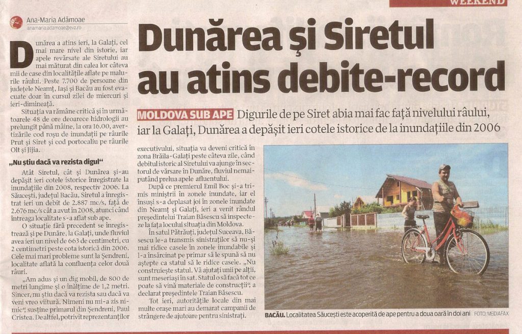
As a result of climate change, especially during the last decade, large-scale floods increased in the temperate belt in Europe in Germany, France, Poland, Serbia, the Czech Republic and Hungary, etc. (see Table 4). At the same time, the intensity, frequency and consequences of floods in countries in the tropical and equatorial belt increased, with a significant and ongoing impact on regions in the interior of these countries e.g., Pakistan, Thailand, the Philippines and Indonesia, etc.
Climate change produced a combination of a number of flood causes: strong hurricane winds, heavy and continuous rainfall, high tides, unpredicted flash flloods, etc., in a number of countries (e.g. the Philippines, Indonesia, Pakistan, Thailand, Bangladesh, India, Japan, Bolivia, Argentina and Ecuador).
In the countries of the temperate belt, the main causes of flooding are usually cyclones and strong winds bordering on hurricane level, etc., which in the past occurred only exceptionally.
At regional level
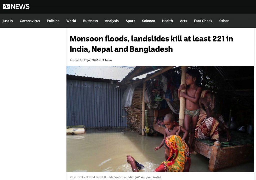
The monsoon rains are an annual cause of seasonal catastrophic floodings, which, in combination with other hazards like landslides, cause numerous victims on a yearly basis (e.g. in the last five years: 60 victims in India in 2015, about 500 victims in India, 57 in Bangladesh and 30 in Nepal in 2017, more than 350 victims in nothern India in 2018, about 200 victims in India, 27 in Pakistan, about 100 in Bangladesh and Nepal in 2019 and , till to middle july 2020, monsoon floods and landslides killed at least 221 people in India, Nepal and Bangladesh (see Fig. 4),
At local level
At local level, floods affecting people’s lives occur most frequently where human activity has taken place without proper assessment, and with no planning or control. The media constantly show reports of high water sweeping through town centres because of illegal, uncontrolled construction, as well as images of huge areas of land flooded as a result of failure to build or maintain hydrotechnical installations.
Floods in populated areas are usually the result of a lack of necessary maintenance of existing drainage systems, growth in settlements and low capacity of drainage systems.
Floods occur where local authorities fail properly to meet their obligations in terms of construction, maintenance of hydraulic structures, the cleaning of river beds, logging and maintenance of drainage in settlements, etc.
Tab. 4. List of some of the bigger floods occurred in Europe in the decade 2010 – 2020
| Year | River basins | Countries affected | Type | Causes | Fatalities |
|---|---|---|---|---|---|
| 2010 | Vistula | Poland | Riverine | Intense rainfall | 9 |
| 2010 | Danube | Slovakia, Serbia, Hungary, Romania, Moldova | Riverine | Intense rainfall | |
| 2010 | Several rivers | Germany, Poland, Czech Republic | Riverine | Intense rainfall | 6 |
| 2010 | Sava | Slovenia | Riverine | Intense rainfall | 3 |
| 2010 | Var | France | Flash flood | Intense rainfall | 25 |
| 2010 | Drin | Albania | Riverine | Intense rainfall | |
| 2011 | Rhine, Oder | Germany | Riverine | Intense rainfall, snow melting | 2 |
| 2011 | Several rivers | Ireland, Italy, France | Flash floods | Intense rainfalls | 2 Ireland. 6 Italy, 6 France |
| 2011 | Cyclone Berit | England | Storm surge |
0 | |
| 2011 | Ebro | Spain | Riverine | Intense rainfall | 2 |
| 2012 | Several rivers | Russian Federation | Flash floods | Intense rainfall | 172 |
| 2012 | Several rivers | United Kingdom | Riverine | Intense rainfall | 9 |
| 2013 | Elbe, Danube, Vltava | Germany, Czech Republic, Austria | Riverine | Intense rainfall | 25 |
| 2013 | Several rivers | Sardinia | Riverine | Intense rainfall | 18 |
| 2014 | Several rivers | Bosnia & Herzegovina, Serbia | Riverine | Intense rainfall | 86 |
| 2014 | Several rivers | Bulgaria | Riverine | Intense rainfall | 16 |
| 2016 | Several rivers | Austria, Belgium, France, Germany, Moldova, Romania | Riverine | Intense rainfall | 20 |
| 2016 | Vardar | Republic of North Macedonia | Flash fllod | Rainstorm | 21 |
| 2018 | Several rivers | Spain, France, Italy | Riverine Flash floods |
Intense rainfall | 13 Spain 16France 36 Italy |
| 2020 | Storm Gloria | Spain, France | Storm surge | Riverine floodings associate to storm | 13 |
| 2020 | Island of Evia, Greece | Flash flood | High winds Intense rainfall | 7 |
| Continent Country | River Lake Sea | Year | Type of flood | Causes | Injured territory | Injured population | Victims | Economic losses |
|---|---|---|---|---|---|---|---|---|
| ASIA | ||||||||
| Thailand | South China Sea | 2011 | Combination – Riverine and Costal Floods | Intensive and long Monsoon rainfalls after 3 Hurricanes | 300 000 km2 | 11 Millions p. | 600 p. | 16 Milliards $ |
| Pakistan | Indi | 2010 | Combination – Riverine, Local drainage and high groundwater levels | Monsoon rainfall with Change model | 350 000 km2 | 13,8 Millions p. | 1500 p. | – |
| Philippines | Island | 2011 | Combination of floods | Hard and long Tropic cyclone. Sea tide | – | 300 000 p. | 1000 p. | – |
| Bangladesh | Gang Brahmaputra | 1998 | Combination – Riverine and Costal Floods | Combination – Monsoons and Tropic Cyclone | 100 000 km2 | 70 Millions p. | 1300 p. | – |
| Bangladesh India Nepal | Gang | 1993 | Combination – Riverine Flooding Costal floods | Intensive Monsoons Rainfall | – | 6 Millions p. | 3084 p. | 8,5 Milliards $ |
| China | Yangtze | 1998 | Riverine flood | Intensive rainfall | – | 180 Millions p. | 3656 p. | 31 Milliards $ |
| 1993 | – | – | – | – | – | 11 Milliards $ | ||
| 1995 | – | – | – | – | – | 8 Milliards $ | ||
| 1996 | – | – | – | – | – | 24 Milliards $ | ||
| South East China | 2011 | Combination Riverine floods Several Mud flows | Intensive and very long rainfall | 12 Provinces | 5 Millions p. | 355 p. | – | |
| Japan | Pacific Ocean | 2011 | Coastal Flooding | Tsunami (Earthquake – 8,9 Richter) | 400 km Sea Cost | 5 Millions p. | 15781 p. | – |
| India | Several rivers | 2005 | Rivering flooding | Intensive and long Monsoon Rainfall | – | – | 700 p. | – |
| 2008 | Rivering flooding | Intensive early Monsoon Rainfall | – | 1,2 Millions p. | 150 p. | – | ||
| 2011 | Rivering flooding | Intensive Monsoon Rainfall | – | – | 335 p. | – | ||
| North Korea | Taedong River | 1995 | Rivering flooding | Intensive rainfall | Secondary effect-hunger 300 000 homelles | 2 Millions p. | 800 p. | 15 Milliards $ |
| Indonesia | India Ocean | 2004 | Tsunami wave | Earthquake(9,0-9,3) near to island Sumatra | 15 countries | 1.7 Millions p. | 283 000p. (9000 tourists) 14100 p. – disappear | 16 Milliards $ |
| NORTH AMERICA | ||||||||
| USA | Mississippi | 1993 | Riverine flooding | Intensive rainfall | 9 states | – | 50 p. | 21 Milliards $ |
| Texas | 2001 | Flash flooding, Tropic Storm ”Allison” | Intensive rainfall | – | – | 23 p. | 6 Milliards $ | |
| New Orleans | 2005 | Combination Revering floods | Hurricane “Katrina” | 233 000 km2 | – | 1836 p. | – | |
| West Virginia | 1972 | Dam break of coal mine | – | – | – | 125 p. | – | |
| SOUTH AMERICA | ||||||||
| Argentina Ecuador Bolivia | Several rivers | 2008 | Riverine floods | Intensive and long rainfall – El Nino | – | 150 000 p. | 50 p. | 16 Milliards $ |
| Brasil | Several rivers | 2011 | Riverine flooding | Intensive rainfall | – | 1 | 35 p. | – |
| Venezuela | Rio San Julian | 1999 | Alluvial fan flood | Rainfall storm | – | – | 19 000 p. | – |
| AFRICA | ||||||||
| Mozambique | Limpopo river | 2000 | Riverine Flooding | Torrential rain | 1400 km2 | 800 000 p. | 800 p. | – |
| The Republic of South Africa | Orange river | 2011 | Riverine flooding | El Niño | – | – | 100 p. | – |
| Algeria | – | 2001 | Flash Flood, Alluvial fan flood | Torrential rain | – | – | 827 p. | – |
| AUSTRALIA | Quenensland Floods Fitzroy Burnett Coudamine Ballone Mary | 2010 | Riverine and Costal flooding | Intensive rainfall and strong wind | 800 000 km2 | 200 000 p. | – | – |
| Continent Country | River Lake Sea | Year | Type of flood | Causes | Injured territory | Injured population | Victims | Economic losses |
|---|---|---|---|---|---|---|---|---|
| EUROPE | ||||||||
| Germany Poland Czech |
Oder | 1997 | Riverine | Intense rainfall | – | – | 115 p. | 6 Milliards $ |
| Poland Czech Hungary Slovakia Servia |
Visla Valtava Danube |
2010 | Riverine | Intense rainfall | 80 000 km2 | 3 Millions p. | 9 p. | – |
| Germany | Rein Oder |
2011 | Riverine | Intense rainfall Melt of snow |
– | – | 2 p. | – |
| Germany Poland Czech |
Several Rivers | 2010 | Riverine | Intense rainfall | – | – | 6 p. | – |
| England | Several Rivers | 1998 | Riverine | Intense rainfall | – | – | 5 p. | 3 Milliards $ |
| – | 2009 | Riverine | Intense rainfall Strong Wind |
– | – | 9 p. | – | |
| – | 2011 | Riverine | Intense rainfall | – | – | – | – | |
| France | Several Rivers South France |
2010 | Riverine | Intense rainfall | – | – | 25 p. | – |
| Mallpas-et Dam | 2011 | Riverine | Intense rainfall | – | – | 3 p. | – | |
| Several rivers | 1959 | Dam-break flood | Dam break | – | – | 421 p. | – | |
| Italy | – | 2000 | Riverine | Intense rainfall | – | – | 5 p. | 8,5 Milliards $ |
| Vaiont Dam | 2004 | Riverine | Intense rainfall | – | – | 9 p. | 9,3 Milliards $ | |
| Ebro | 2011 | Riverine | Intense rainfall | – | – | 6 p. | – | |
| 1963 | Devastating flood | Landslide | – | – | 3000 p. | – | ||
| Spain | – | 2010 | Riverine | Intense rainfall | – | – | 3 p. | – |
| – | 2011 | Riverine | Intense rainfall | – | – | 2 p. | – | |
The consequences of floods can be counted in:
- Human casualties.
- Social and economic losses.
- Areas affected.
- Environmental contamination.
- Destruction of cultural heritage.
Floods typically have primary and secondary consequences.
– The primary consequences include:
– Damage or partial/total physical destruction of bridges, vehicles, buildings, houses, communication systems, sewer systems, road networks and other key infrastructure;
– Casualties: drowning of people or livestock, as well as resulting epidemics and diseases.
– Secondary consequences include:
– Water supply made more difficult because of water contamination, resulting in shortage of clean drinking water.;
– Proliferation of diseases: unhygienic living conditions and diseases spreading through water;
– Food supply made more difficult, resulting in food shortages. Entire crops may be destroyed;
– Vegetation: many species may die;
– The consequences of floods are long term;
– Economic hardship caused by temporary declines in tourism, increases in the price of food and recovery costs.
– Benefits of floods: While floods can have many destructive effects, they can also make the soil more fertile, enriching it with multiple nutritive substances. For instance, since the fifth century. B.C., the importance of river Nile was known as it played a fundamental economic role for the Egyptian people, making arid and desert lands fertile. Every year, in summer the river flooded the neighboring territories; the waters retreated into the riverbed in autumn, leaving an extremely fertile layer of mud (silt) on the fields.
As a natural phenomenon, floods cannot be avoided. Causes of floods are complex, and insensitive human activity is an important factor alongside natural ones, such as heavy rain, melting snow, etc.
The causes of floods include human activities, e.g.:
- reductions in the soil’s natural ability to retain water caused by land uses such as logging which increases the speed of the natural flow (see Fig. 6);
- corrections in river beds;
- building in areas at risk of ground failure floods;
- climate change mainly caused by human activity, which plays a part in increasing the probability of flooding and the resulting negative consequences.
Human activity is a reason for flooding in many cases. Changes in terrain and river beds, inadequate maintenance of hydraulic installations and failure to clean up river beds all increase the probability of flooding.
The consequences of floods are strongly influenced by human behaviour.
Human behaviour plays a large part in increasing the consequences of floods, on the one hand and in mitigating them, on the other hand.
Activities that increase the negative consequences of floods include:
– growth in population centres and production zones in floodable plains and other areas at risk that is the construction of housing in flood-risk areas (see. Fig. 2.1 c and Fig. 10).
– logging and destruction of vegetation, which sharply increase the negative impact of floods.
– obstruction of riverbeds.
– inadequate maintenance of hydraulic structures and lack of control.
– lack of proper maintenance of drainage in populated areas.
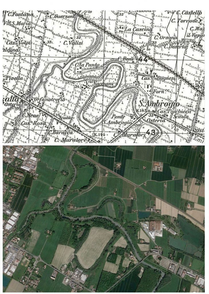
– the modification of riverbeds. For instance, in the mid-lower part of the Modena plain, the river length of Panaro and Secchia Rivers have been reduced to about 12% of their length by artificial meander cut-offs carried out since the 19th century to reduce flood hazard. In this way, along long stretches of their course, the rivers have assumed the aspect of artificial watercourses. Since the cut-offs did not adequately reduce flood hazard, “flow regulation systems” (see Fig. 9) were constructed to East and West of Modena (see Fig. 9). The morphology and evolution trend of the Panaro and Secchia Rivers have been conditioned by direct and indirect human activities over the past two centuries, which is similar to what has been recorded in other Italian rivers (Fig. 7)
Environmental impact resulting in climate change directly influences the consequences of floods , as it increases their intensity and in some cases can hinder potential prediction.
Human behaviour that mitigates flood consequences includes:
– development and implementation of national disaster prevention policies;
– building defensive installations;
– organisation of warning systems for the population concerning flood risks;
– development and maintenance of protection plans;
– implementation of risk-prevention training, in areas at risk of flooding;
– improvement of prediction systems;
– permanent monitoring.
Floods can be predicted to a large extent thanks to modern technologies and communications, as well as on the basis of accumulated statistical data. This makes it possible to establish in advance the time, nature and scale of floods.
The meteorological situation around the world is monitored with meteorological satellites. The information obtained about dangerous events and phenomena is processed and developments in the situation are predicted on the basis of the respective models. Together with the information acquired by national hydro-meteorological services, the data obtained enables predictions of floods to be compiled. Weather forecasts, on which flood prediction depends, indicate only the likelihood of precipitation in a large area, not the certainty of occurrence in specific locations.
As concerns the riverine floods, the bigger the stream, the greater the ability to predict the rising of the water level in a large river, e.g. Danube, Volga, Rhine, Dnepr, etc. It is in fact a phenomenon that occurs slowly, taking from several hours to several days. This allows constant monitoring and especially preventive actions. In contrast, the level of the water of small rivers or streams can grow very quickly, with reduced intervention times. In these cases, it is not always possible to predict flooding, let alone when and where they will occur.
The scale of flooding caused by spring waters can be predicted up to a month or more beforehand. To that end, the depth of the snow cover is measured, along with soil humidity levels and temperature, etc.
Floods caused by strong storm winds can be predicted from one to two hours to one to two days before they occur.
Prediction of a flood caused by a tsunami is based on timely assessment of the location of the epicenter and magnitude of the earthquake, after which a set model is used to make a prediction and warn the endangered parties.
When predicting floods for individual locations, account must be taken of the natural regime of the waterways, as influenced by the presence of embankments, dam walls, canal locks and canals, etc.
Modern technologies allow the accurate prediction of meteorological conditions and in combination with the results from national hydrotechnical services enable the origin and the development and extent of floods to be predicted. This makes it possible to avoid being caught unawares and prevent panic, to plan more effectively and to implement activities to protect the population and safety measures when necessary.
There are many ways of preventing floods, which, if implemented holistically, can lead to a reduction in their occurrence.
Flood prevention can be implemented at the following levels:
- World level – through environmental protection, addressing climate change and through development of forecasting and prediction systems;
- Regional level – through the establishment of prevention systems and prediction and early-warning systems for flood risks, such as implemented after the tsunami in the Indian Ocean. It was due to an undersea earthquake (M = 9.1) which struck Indonesian Island of Sumatra killing at least 225,000 people across a dozen countries in December 2004;
- National level – through the development and implementation of a national policy for combating disasters and, in particular, floods;
- Local level – through the implementation of a range of measures: development and maintenance of the respective plans for protection, control and activities designed to prevent floods and reduce their impact, construction and maintenance of hydraulic installations, etc. As concerns hydraulic structure, for instance, in the northern and central Apennnes (Italy) since several decades, flow regulation devices were constructed in areas adjacent to the courses of some rivers (Parma, Enza, Secchia, Panaro, Arno, Tevere and others) in order to control the hydrological hazard of riverine floods. These structures (named “Flow regulation systems”) consist principally of a regulating dam built across the riverbed and a storage basin bordered by embankments. Their most important function is to reduce the flood peak, that is, they intervene on only a limited scale (Fig. 9).
- Measures for personal protection which should include school training, cultivation of individual awareness of the existence of a flood risk in the places where people live or stay as tourists, knowledge of the steps to be taken both during and after flooding and a minimum of first aid skills, etc.
By implementing a consistent and well thought-out policy at world, regional, national and local level, it is entirely possible to mitigate the negative consequences of floods, especially those affecting human health and life, the environment, cultural heritage, economic activity and infrastructure.
Combating floods involves activities implemented in accordance with long-term plans, as well as short-term activities.
Examples of long-term activities include the building of various protective installations and their annual maintenance, as well as the development and maintenance of various protection plans.
Short-term activities are prepared annually and are implemented when there is a danger of flooding. Examples include the advance provision of waterproof sheeting, sandbags, water pumps and electricity generators, making organisational arrangements on the basis of the existing plans and analysis of systems for control and warning of flooding. The clearance of drainage systems and the flowability of river channels are extremely important and are the direct responsibility of local authorities.
Effectiveness in combating floods is determined not only by the climate specifics and the regime of the rivers in a given region, but also by the specific location of the urban centers and the availability of hydraulic structures capable of regulating water outflow (Fig. 9). However, the effects of flooding are reduced primarily by measures that prevent or restrict the urban expansion in areas subject to floods such as the high water riverbeds (Fig. 10).
Experience shows that it is entirely possible to avoid catastrophic consequences of floods when the relevant predictions are taken into account appropriately and on a timely basis and the respective activities are implemented in line with local conditions. Arrangements for timely information about the danger of flooding and training in proper responses and giving first aid are factors which considerably mitigate the consequences.
In order to adequately respond and avoid panic in the event of flooding, it is necessary to be prepared in advance so that everybody knows what to do.
Firstly, people must be aware of whether the areas where they live are at risk of flooding, as well as the possible causes thereof.
Secondly, it is very important for people in flood-risk areas to take out flood insurance.
Thirdly, plans for individual protective action against the risk of flooding must be prepared.
Steps for personal protection include:
Prior to flooding and during the alert:
- proper acquaintance with flood protection plans;
- the local authorities start to implement certain aspects of the protection plans: informing the population in danger, stepping up monitoring of the areas at risk and reminding people of the danger signs and warning signals, etc.;
- evaluate if you need to secure the car or other property: it can be dangerous;
- if you need to evacuate, first evaluate the path and avoid flood prone areas;
- when ordered to evacuate, do so without delay so as to avoid subsequent danger. Leaving the threatened zone on your own at a later stage is very dangerous;
- if you have poisonous or other hazardous substances, ask experts what to do with them. If you have time, store paint, pesticides, fertilizers and other hazardous materials in plastic buckets off the floor;
- move furniture and electrical appliances upstairs.
During flooding:
- listen to information and instructions broadcast on radio and TV;
- try to stay calm, avoid panic;
- in the event of sudden flooding or if you believe a flood is approaching your home (based on water level, build-up of rain clouds, heavy rainfall or your home’s location next to a spring), move immediately to higher ground without waiting for instructions to do so; this has to be your own decision;
- it should be remembered that spring valleys (even when dry), canyons, gullies and drainage canals are the most dangerous places in the event of sudden floods;
- do not go through road underpasses;
- if you are on holiday you should know the relevant advice and adhere to the instructions of the local authorities. Experience shows that the largest losses are usually suffered by tourists;
- if you are in the flooded area:
- go to the top floor; climb onto the roof if necessary;
- if you are in a forest, climb onto a tall tree;
- if you are in water, try to move to a dry zone;
- if you are in fast-moving water, do not move against the flow or with the flow, but move at an angle to the flow in a shoreward direction.
- if you have been given instructions to evacuate, proceed as follows
- if you have time, move essential items to the top floor;
- turn off the electricity, water and gas as instructed (do not touch electrical equipment if you are wet or standing in water);
- if you have time, board up the front door and the windows.
- do not cross any moving water; if you have to, check the depth of the water in front of you with a stick;
- do not drive your car through flooded areas, and if the water level around the car starts rising leave the car immediately and move to higher ground.
- if you have to remain in your home during the flood:
- listen to the information on radio and TV continuously;
- stay on an upper floor if possible;
- put all documents, money, valuables and most important medicines in a suitable bag;
After flooding:
- after evacuation, you can return to your home only if permitted by the local authorities;
- Do not pass along flooded roads: there may be chasms, potholes, open manholes or severed wires. In addition, water may be contaminated by fuel or other substances
- Pay attention to areas where the water has receded: the road surface may be weakened and collapse
- open the doors and windows and ventilate the house;
- do not turn on the electricity until the electrical system has been examined by an expert;
- examine the gas system;
- do not use unchecked water or food.
Within the framework of the Italian Projest IONONRISCHIO, which means “I do not risk”, a card containing useful information on the behaviour to adopt in case during the alert, during and after a flood was prepared and the card can be downloaded at: http://www.iononrischio.it/download/2018_inglese/SCHEDA_ALLUVIONE_ING.pdf
Maps may be geographical, economic or physical and include various meteorological maps for rainfall, river runoffs and winds. The scale may vary depending on their purpose. Flood maps should make it possible to predict the threatened areas and allow for the planning of defensive measures. It is better to use topographic maps or maps with a horizontal scale because data on height above sea level are very important when determining flood risks and planning flood defence measures. Digital maps combined with GPS are the most useful.
At river basin level, the following are prepared:
– maps of all regions in danger of being flooded: Flood hazard maps
– maps of specific areas where there is a risk of flooding: Flood risk map
Flood hazard maps, at small or/and at large scale, show the expected extent and water levels of a flooded area in three scenarios: a low probability scenario or extreme events, in a medium probability scenario (at least with a return period of 100 years) and a high probability scenario.
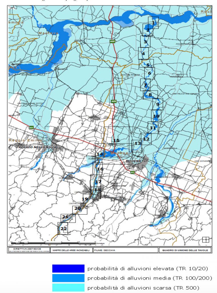
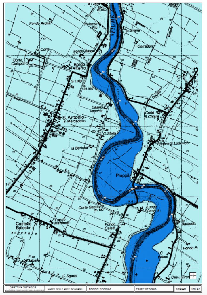
As concerns an example of flood hazard maps in Italy, the Po River Basin Authority (AIPO) has been active for long time in identifying and mapping flood hazard areas of the entire catchment of the Po River. AIPO applied a simplified method based on the perimeter of historical floods thus identifying three distinct flood scenarios: low probability scenario (Return period 500 years), medium probability scenario (Return period 100 – 200 years), high probability scenario . (Fig.12.a and Fig.12.b).
Flood risk maps are prepared for the areas flooded under these scenarios showing the population, economic activities and the environment at potential risk of flooding, and other information that may be useful to include, e.g., other sources of pollution.
The maps are used to determine regions which may be affected by floods and the losses which may result. Measures to protect the population and long-term activities to mitigate the potential consequences of flooding are planned on the basis of these maps.
The maps of the regions under threat of a flooding cover the geographical locations that can be flooded and reflect:
- floods that are less likely to occur or cases of unforeseen events;
- floods with medium probability to occur /probability of second occurrence – more than 100 years /;
- floods with high probability to occur.
On the bases of prediction on these maps, several activities with long and short term character aiming to prevent or to reduce flood consequences are planned and implemented and planes for defense are elaborated.
The maps of the regions under risk of flood show the possible negative consequences of the flood and reflect:
- a project number of population that could be possibly affected;
- type of economic activity in the region that will be possibly affected;
- installations for complex prevention and control of contamination, that may cause additional contamination due to flood-caused technical failures.
On the bases of prediction on these maps the activities for protection of the damaged populayion on regional and local level, the long and short term activities are planned. An individual plan for action at flood danger for you and your family can be prepared on the bases of these maps.
You are entitled to familiarize yourself with the maps and to receive the information you require concerning danger of flood, and if a proper organization is in place, to receive such maps or excerpts thereof.
Even more – it is the obligation of every citizen to be aware of what dangers are possible in his living location. It is especially important to familiarize yourself with the map and to check whether the home you live in, the school you study in, or your work place are located in zones in danger of flood. On the basis of that you can request information for the existing protection plan and the steps you need to undertake in case of danger, during, and after a flood.
The maps are prepared, maintained and kept by the respective institutions in a country – normally these would be the Basin directorates and Civil Protection Service.
From the map you can learn about the obligation of the local authorities for prevention from flood at sudden danger from flood.
From the maps you can learn about the obligation of the local authorities for prevention from flood risk and to insist to be implemented.
From the maps on Internet you can get orientation about the existing rivers, springs, dams and other hydro technical facilities which can cause flood.
At school you can create you own map of the danger zones from flooding for the place where you live, the way to school and at school to predict and discuss what you have to do in case of flood if you are any of these places. Before going abroad with your parents on holiday you can learn from the Internet map about the existing danger from some types of floods.
We have prepared a map of the floods all over the world on the bases of “Google Maps”.
You can look at the map and decide whether there is a thread from flood for a place you wish. You may try to make a prediction about the areas threatened by flood. The icons of Google have been used. You can add to any place threatened by flood or hurt by flood: pictures, texts, drawings, videos etc. This map can connect with GPS navigator and we can exactly to the place we want – where we live, the place we will go on holiday with our parents.
View Floods Prevention – ECRP (BG) in a larger map